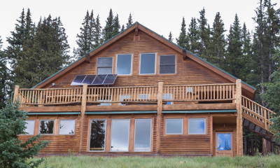
The Huts > 10th Mountain Division Hut Association > Sangree M. Froelicher Hut
Sangree M. Froelicher Hut
Formerly the privately owned Belvedere Hut, the Sangree M. Froelicher Hut was purchased in 2003 by 10th Mountain, thanks to the generous support of many donors. The hut’s name honors Staff Sergeant Sangree Mitchell Froelicher, 1st Platoon, Company B, 1st Battalion, 86th Mountain Infantry, who was killed in action in Sassomalare, Italy, on March 4, 1945. The hut was built in 1998. 10th Mountain is also pleased to offer the Alpine Resource Center at Sangree’s Hut. The Alpine Resource Center is a unique 600 square foot area with its own heat stove, and a comfortable reading, study, and seminar area on the lower level of the hut. For more information on Sangree M. Froelicher and his heroic story please read the Sangree M. Froelicher Extended History.
Hut Information
Owned By
10th Mountain Division Hut Association
Open
Summer / Winter
Winter Mileage*
3.1
Closest Town
Leadville
Hut Elevation
11,650 '
Cumulative Elevation Gain *
1,477'
Layout
Upstairs: 1 room with 4 single beds, 1 room with 3 single beds, and 10 single beds in a communal sleeping area.
*from Buckeye Gulch Trailhead
Amenities
Heat
Wood
Oven
Wood
Refrigeration
No
Water
Cistern, Stream*, Snow Melt**
Toilet
Outhouse
Ada Accessible
No
Sauna
No
Fire Ring
Yes*
Grill
No
Dogs
No
Charging
None
Gear Cart
No
* Summer only
** Winter only
Details
- Firewood, starter paper, matches, axes
- Propane for kitchen burners
- Cupboard or closet for cold food storage
- Snow collection buckets and large pot for melting snow on wood-burning heat stove (suggested use of snowmelt water is for drinking)
- Hand pump in kitchen sink dispenses water from roof-top cistern (suggested use of cistern water is for cleaning only)
- Pots, pans, potholders, dishware, cooking and eating utensils, percolator, salt & pepper
- Paper towels, dish soap, hand sanitizer, cleaning supplies, trash bags, toilet paper
- Solar powered lights
- Mattresses, pillows
Book This Hut
Visit our Online Booking Platform to search for availability and book this hut.
Location
Official 10th Mountain Division Map
CalTopo
Winter Map : Continental Divide E/W + Betty Bear Map
View / PrintNational Geographic
Map : Breckenridge/Tennessee Pass
USFS
Map : San Isabel National Forest
Trailheads/Routes
The main winter route into the Sangree M. Froelicher Hut follows a combinations of ski trails and old road cuts. Most of the climbing is in the first 2/3rds of the ski in. The first part of the ski trail crosses private property so please be respectful and stay on the marked trail.
Routes
Sangree M. Froelicher Hut from Buckeye Gulch Trailhead/Standard Winter Route
Total Mileage
3.1
Trailhead Elevation
10,180'
Cumulative Elevation Gain
1,477'
Sangree M. Froelicher Hut from Ski Cooper Trailhead
Total Mileage
5.6
Trailhead Elevation
10,480'
Cumulative Elevation Gain
1,831'
Cumulative Elevation Loss
621'
Hut to Hut/Sangree M. Froelicher Hut to Emmelyn Hut
Total Mileage
2.7
Trailhead Elevation
11,650'
Cumulative Elevation Gain
417'
Cumulative Elevation Loss
936'
The best access into the Sangree Froelicher Hut during the summer is hiking or biking along the marked winter ski trail. The Mt Zion Road does run near the hut but is extremely rough even for 4wd vehicles and is not recommended for summer access. Vehicle access is never guaranteed to any hut at any time.
For day hikes around Sangree Froelicher you drop down into the basin below Buckeye Peak and hike to Buckeye Lake or hike to the top of Buckeye Peak itself for beautiful views of the Sawatch Range.
Summer Water Source Information
Summer Hut Information PDF
Routes
Hike on Trail/Dirt Road Combo Buckeye Gulch Trailhead to Sangree M. Froelicher Hut
Total Mileage
3.1
Trailhead Elevation
10,180'
Extreme 4WD High Clearance to Sangree M. Froelicher Hut via FS Rd 109 (aka Mt. Zion Rd)
Trailhead Elevation
0'

Hut-Specific Weather
This Afternoon : Snow showers likely and a slight chance of thunderstorms. Mostly cloudy, with a high near 40. West wind 10 to 15 mph. Chance of precipitation is 70%. New snow accumulation of less than half an inch possible.
Tonight : Snow showers and a chance of thunderstorms. Cloudy, with a low around 25. South wind around 5 mph. Chance of precipitation is 90%. New snow accumulation of 1 to 3 inches possible.
Saturday : Snow showers and a chance of thunderstorms. Cloudy, with a high near 30. East southeast wind around 5 mph. Chance of precipitation is 100%. New snow accumulation of 5 to 9 inches possible.
Saturday Night : Snow showers and a chance of thunderstorms. Cloudy, with a low around 22. Northwest wind 5 to 10 mph. Chance of precipitation is 90%. New snow accumulation of 1 to 3 inches possible.
Sunday : Snow showers before noon, then snow showers and a chance of thunderstorms. Mostly cloudy, with a high near 34. Northwest wind 10 to 15 mph. Chance of precipitation is 90%. New snow accumulation of less than one inch possible.
Sunday Night : A chance of snow showers and a chance of thunderstorms before midnight. Mostly cloudy, with a low around 22. West northwest wind 5 to 15 mph. Chance of precipitation is 50%. Little or no snow accumulation expected.
Monday : Mostly sunny, with a high near 38. West wind 5 to 20 mph.
Monday Night : Partly cloudy, with a low around 25. West southwest wind around 15 mph.
Tuesday : Sunny, with a high near 43. West wind 15 to 20 mph.
Tuesday Night : Mostly clear, with a low around 26. West southwest wind around 15 mph.
Wednesday : A slight chance of snow showers and a slight chance of thunderstorms after noon. Mostly sunny, with a high near 46. West wind 15 to 20 mph.
Wednesday Night : A slight chance of snow showers before midnight. Partly cloudy, with a low around 26. West southwest wind around 15 mph.
Thursday : A chance of snow showers after noon. Mostly sunny, with a high near 47. West southwest wind 10 to 15 mph.
Thursday Night : A slight chance of snow showers before midnight. Partly cloudy, with a low around 30. South southwest wind 10 to 15 mph.
Contents
Notices
Avalanche Hazard Information
Colorado is known for its avalanche prone snowpack. A number of the suggested routes to 10th Mountain Division Huts pass through or are next to terrain that may be prone to avalanches. Accordingly, pick the suggested route that most suits your group and its abilities, carry appropriate equipment, and always exercise prudent backcountry travel techniques when passing through avalanche prone terrain. Remember, avalanches can occur in forested areas and can run into forested areas from open slopes. Moreover, a number of huts booked are situated in the midst of extreme avalanche terrain. Many other huts, while located in more modest terrain, still have access routes that cross avalanche paths.
We strongly suggest that someone in every group be experienced in evaluating avalanche and snow stability hazards and practicing prudent backcountry and winter mountain travel techniques. For up-to-date avalanche information for all of Colorado, visit the website for the Colorado Avalanche Information Center (CAIC). Another excellent resource is the Forest Service National Avalanche Center website. While this site doesn’t have local forecasts, it does have a wealth of information on backcountry travel in avalanche terrain and snow science, as well as tutorials on some basic skills and snow science.
We recommend that you start checking the Colorado Avalanche Information Center (CAIC) website regularly before your trip to see how conditions are evolving. Study your maps to see what type of terrain you will be traveling through to see if there are alternative routes that might be feasible if snow stability conditions deteriorate. During most of the winter, travel to the huts, other than those in the Braun Hut System and the Friends’ Hut, is possible with a relatively minor degree of risk. However, if your trip falls within a period or cycle of high or extreme instability, you must make the decision of whether or not to go. The huts are not closed for avalanche hazard reasons.